


| Status: | Partial |
| Difficulty: | Advanced |
| Uses: | Mt Biking & Hiking & Equestrian |
| Length: | 5 miles |
| Start: | 6,758' |
| End: | 8,817' |
| Min: | 6,758' |
| Max: | 8,868' |
| Gain: | 2,416' |
| Loss: | -356' |
| fly your trail in 3D | |
 |
Google Earth KML file
Download KML file above, open in Google Earth to see this trail in 3D! |
| don't get lost |
| GPX file (right click to download)
Download GPX file above, upload the track to your GPS or smartphone and you'll always know where you are!! |
There are four different trails that connect between the Corral Creek trailhead and the Johnstone and Hyndman trailheads 12 miles up the East Fork of the Big Wood River. This allows for several loop and up-and-over options for both hikers and mountain bikers. Logistically, the Pioneer Cabin to Long Gulch and Johnstsone Cr. to N. Fork of Hyndman (#206 to #165) loops require minimal car shuttling. Mountain bikers will find the Pioneer Cabin to Johnstone Cr. ride (#122 to #206) to be a challenging climb and a technical, sometimes harrowing downhill. It is also possible to descend the N. Fork of Hyndman Cr. (#165). The switchbacks beneath the cabin are not well maintained, but the trail below that is usually in pretty good shape. For the fit rider, linking either of these rides with the Bear to Parker Gulch trail (#121) creates a huge 30-mile loop. Hikers or mountain bikers planning any up-and-over routes will have to shuttle a car out the East Fork of the Big Wood River.
Directions: Drive south on Hwy 75 to the East Fork stoplight (5.5 mi). Turn left onto East Fork Road and continue 6 miles on pavement and 1.3 miles on dirt to the Hyndman Creek junction (7.3 mi). Turn left up Hyndman Creek to the second private drive (2.3 mi). Bear left into the creek bottom and left again after crossing the creek to the Johnstone trailhead (1.1 mi).
*For more detailed descriptions, topo maps, and information on the history, geology, and wildflowers of the Wood River Valley pick up a copy of Exploring Sun Valley online or find it at one of several local shops.
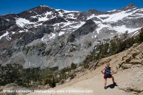 |
| High alpine views on Johnstone |


