

STANDALONE TRAIL MAP
TRAIL INFORMATION

Details
| Status: | Closed |
| Difficulty: | Intermediate |
| Uses: | Mt Biking & Hiking & Equestrian |
| Length: | 4.68 miles |
| Start: | 7,403' |
| End: | 8,663' |
| Min: | 7,403' |
| Max: | 9,043' |
| Gain: | 1,888' |
| Loss: | -635' |
| fly your trail in 3D | |
 |
Google Earth KML file
Download KML file above, open in Google Earth to see this trail in 3D! |
| don't get lost |
| GPX file (right click to download)
Download GPX file above, upload the track to your GPS or smartphone and you'll always know where you are!! |
Trail Info
REMARKS:
Galena Lodge reopens for the summer season on June 7th.
Trailhead Forecast
Snowfall
New Snow last 12 hours: 0". New Snow last 24 hours: 0".Description / Access Information
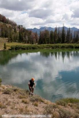
Titus Lake Trail:
The trail to Titus Lake is popular route that is accessible from a pullout near Galena Summit. The trail to the lake can be approached from Galena Lodge too, but its much more demanding coming at the lake that way. This trail is not recommended for bicyclists, but it is open to that use, and some people like its very challenging and technical character.
The Titus Lake Trail runs all the way from Galena Summit to Galena Lodge, but the shorter segment, from the summit to the lake is a 1.7-mile one-way trip. This highrer, out-and-back section weaves through a shady forest with nice views of the Boulder Mountains and the upper Titus drainage. The route (3.4 miles total) is a good hike that is suitable for some kids. The Titus Lake Trail is suitable for most anyone who is willing to take their time and turn around if the going appears to be getting too demanding.
Energetic people in your group can hike from the summit parking to the lake, and then continue on to the lodge. It is about a 6-mile trip, end to end, summit parking to lodge.
Approached the other way, from Galena Lodge, the trail to Tutus Lake starts out as a two-track road that is not very steep. After a while the trail turns into a singletrack. The grade stays pretty manageable, but. steep for around 2.5 miles. Between 2.5 and 3.5 miles is the steepest climbing, with the trail utilizing switchbacks to gain elevation. Soon after the trail breaks over and you are at the lake - about 4 miles from the lodge. The trail continues on past the lake to meet Highway 75 and the Galena Summit/Titus Trail parking area.
Some people like to ride up the highway on their mountain bikes to access the high end of the trail, but it's not a very popular option. Some come up the highway, and some use the Old Toll Road Trail to access the top, high trail segment to the lake. Its around 6 miles up the highway from Galena Lodge. After riding to the lake, some people do continue on along the Titus Lake Trail; to ride down to the lodge on it. This is not a very popular option, and the trail is not really recommended for bicycles as it includes many technical challenges. To each his own.
Depending on the time of the year, the trail can be dusty and loose with soft sections and rocky sections. The trails on the west side of Highway 75 see more equestrian traffic than other trails in the area. Watch for others and watch for those who may be approaching from around blind corners. Take it easy and share the trails.
Directions:
From Ketchum, head north on Highway 75 to Galena Lodge to reach the low end of the Titus Lake Trail. The distance is around 24 miles from Ketchum to Galena Lodge. To reach the upper parking area for the Titus Lake Trail, continue past the lodge for another 6 miles or so to reach the high parking area for the Titus Lake Trail. As you are climbing up the highway you will find this parking area just shy of the summit and on the right side. The start of the high end of the trail is on the opposite the parking area - on the other side of the highway.
At Galena Lodge, for the low end of the trail, people with horse trailers usually park in the highway pullout, or in over the bridge, where there is limited room for horse trailer parking. The highway pullout and road over the bridge are on the left side of the highway (as you are coming up from Ketchum). Others can park there too, or in the lodge's main parking lot, which is on the other side of the highway, adjacent to the lodge.
The low end of the Titus Lake Trail is accessed on the side of the highway that is opposite the lodge - on the highway pullout side. Cross the Wood River and head uphill on a two-track road that passes by the cabins and yurts used as housing by the people working at the lodge. You want to be heading up the Titus drainage, on Titus Creek Road, moving toward the Titus Trail. After a short distance the two-track splits, stay right to begin up the Titus Lake Trail. It is still a two-track road here, but after a while it turns into singletrack.
*For more detailed descriptions, topo maps, and information on the history, geology, and wildflowers of the Wood River Valley pick up a copy of Exploring Sun Valley online or find it at one of several local shops.
Photos
 |
| Titus Lake |


