

STANDALONE TRAIL MAP
TRAIL INFORMATION

Hyndman Creek Trail #166
// track pieces: 522, // elevation pieces: 522
Details
| Status: | Closed |
| Difficulty: | Advanced |
| Uses: | Mt Biking & Hiking & Equestrian |
| Length: | 3.6 miles |
| Start: | 7,045' |
| End: | 8,722' |
| Min: | 7,045' |
| Max: | 8,722' |
| Gain: | 1,729' |
| Loss: | -46' |
| fly your trail in 3D | |
 |
Google Earth KML file
Download KML file above, open in Google Earth to see this trail in 3D! |
| don't get lost |
| GPX file (right click to download)
Download GPX file above, upload the track to your GPS or smartphone and you'll always know where you are!! |
Trailhead Forecast
Snowfall
New Snow last 12 hours: 0". New Snow last 24 hours: 0".Description / Access Information
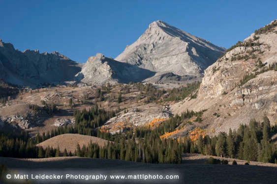
Hyndman Creek Trail #166: This popular trail follows an old mining road through aspen groves and wildflower meadows before climbing into the spectacular glaciated basin between Duncan Ridge and Cobb Peak. The scenery only improves as you pass a small lake and climb hanging meadows blanketed with more flowers to the impressive saddle above Wildhorse Canyon.
Many people continue from here up the Class 3 SE ridge of Hyndman Peak, the tallest in the Pioneers. The initial 2.3 miles of trail make a nice, stand-alone mountain bike ride that can be continued up the switchbacks into Big Basin. This is a great way to access (and quickly exit) the numerous off-trail hikes in the alpine basins above. Climbers willing to explore may find potential in the quartzite walls at the mouth of the canyon. Geologists will be awed by the cross-sections of ancient sedimentary rocks exposed by scouring glaciers.
Directions: Take Hwy 75 south from Ketchum (5.5 mi) or north from Hailey (6.3 mi) to the stoplight at East Fork Rd. Turn east and drive 6 miles on pavement and 1.3 miles on dirt to the Hyndman Creek jct (7.3 mi). Turn left onto Hyndman Cr. Rd. #203 and continue to the second private drive (2.3 mi). Bear left into the creek bottom and left again after crossing the creek. Follow the main road to the trailhead (2.6 mi).
*For more detailed descriptions, topo maps, and information on the history, geology, and wildflowers of the Wood River Valley pick up a copy of Exploring Sun Valley online or find it at one of several local shops.
Photos
 |
| Hyndman Creek |


