

STANDALONE TRAIL MAP
TRAIL INFORMATION

Details
| Status: | Open |
| Difficulty: | Intermediate |
| Uses: | Mt Biking & Hiking & Equestrian |
| Length: | 0.3 miles |
| Start: | 8,687' |
| End: | 8,811' |
| Min: | 8,687' |
| Max: | 8,811' |
| Gain: | 124' |
| Loss: | 0' |
| fly your trail in 3D | |
 |
Google Earth KML file
Download KML file above, open in Google Earth to see this trail in 3D! |
| don't get lost |
| GPX file (right click to download)
Download GPX file above, upload the track to your GPS or smartphone and you'll always know where you are!! |
Trailhead Forecast
Description / Access Information
Baker Lake Trail #818:Great easier 1.5-mile long hike from Baker Lake Trailhead to the lake. This hike combines the short #818 trail with the lowest 1.3 miles of the Baker Creek-Norton Creek Trail #138. Baker Lake is beautifully positioned beneath impressive, red rock spires. The casual hike to the lake makes this a great hike for younger kids or toddlers in backpacks. It is one of the more popular lake hikes in the valley, so expect to see others on the trail.
Mountain bikers can ride to the lake, or attempt the Baker to Norton Connector that leads to a fun downhill.
Directions: Head north on Highway 75 to the Baker Creek Road (15.4 mi). Turn left/west and stay on the main dirt road for about 10 miles to its terminus at the Baker Lake Trailhead.*For more detailed descriptions, topo maps, and information on the history, geology, and wildflowers of the Wood River Valley pick up a copy of Exploring Sun Valley online or find it at one of several local shops.
Photos
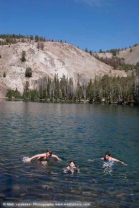 |
| Baker Lake |


