

STANDALONE TRAIL MAP
TRAIL INFORMATION

Cow Creek Short Cut Tr. #930
// track pieces: 202, // elevation pieces: 202
Details
| Status: | Open |
| Difficulty: | Intermediate |
| Uses: | Mt Biking & Hiking & Equestrian & Motorcycle & eBikes |
| Length: | 0.6 miles |
| Start: | 6,912' |
| End: | 6,793' |
| Min: | 6,748' |
| Max: | 6,915' |
| Gain: | 64' |
| Loss: | -183' |
| fly your trail in 3D | |
 |
Google Earth KML file
Download KML file above, open in Google Earth to see this trail in 3D! |
| don't get lost |
| GPX file (right click to download)
Download GPX file above, upload the track to your GPS or smartphone and you'll always know where you are!! |
Trail Info
REMARKS:
Trails are dry and open. The WRTC/KRD volunteer moto crew has been clearing trails of deadfall.
August 13th Forest Service reports:
• A band is on top of Warfield.
Trailhead Forecast
Description / Access Information
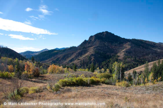
Cow Creek Shortcut Tr. #930: This trail provides a link between the east leg of the Cow Creek Trail No. 180 and the Cow Creek Connector Tr. No. 153. The trail contours through several small aspen groves tucked into a spring-fed basin. There are great views of the fire-scarred Mahoney Butte across the valley. This is also a great hike to appreciate and photograph the aspens turning yellow in the fall.Directions to the Greenhorn Trailhead: At the intersection of Highway 75 and Greenhorn Road (at the Greenhorn/East Fork traffic signal, which is about 5 miles south of Ketchum, and approx. 6 miles north of Hailey) go west to follow the Greenhorn Gulch Road for 3.7 miles to its end at the Greenhorn Trailhead.
*For more detailed descriptions, topo maps, and information on the history, geology, and wildflowers of the Wood River Valley pick up a copy of Exploring Sun Valley online or find it at one of several local shops.
Photos
 |
| Cow Creek Connector in fall |


