

STANDALONE TRAIL MAP
TRAIL INFORMATION

Pioneer Cabin Trail #122
// track pieces: 338, // elevation pieces: 338
Details
| Status: | Open |
| Difficulty: | Advanced |
| Uses: | Mt Biking & Hiking & Equestrian |
| Length: | 3.6 miles |
| Start: | 6,944' |
| End: | 9,452' |
| Min: | 6,944' |
| Max: | 9,493' |
| Gain: | 2,809' |
| Loss: | -307' |
| fly your trail in 3D | |
 |
Google Earth KML file
Download KML file above, open in Google Earth to see this trail in 3D! |
| don't get lost |
| GPX file (right click to download)
Download GPX file above, upload the track to your GPS or smartphone and you'll always know where you are!! |
Trailhead Forecast
Snowfall
New Snow last 12 hours: 0.34". New Snow last 24 hours: 0.8".Description / Access Information
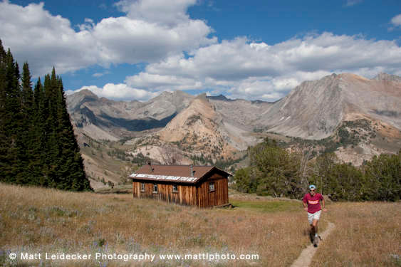
Pioneer Cabin Trail #122: A popular day hike to a charming rustic cabin and spectacular views of the Pioneer Mountains.
The trail to the Pioneer Cabin is one of the area’s most popular hikes. It climbs through more than 23 switchbacks up a forested ridge and across a flower-decorated plateau to some of the best vistas in the valley.
The cabin, situated at the brink of a steep drop into the North Fork of Hyndman basin, was modeled after alpine huts in Europe. It was built by the Sun Valley Company in 1938 to make skiing in the Pioneer Mountains more accessible for the Alpine Touring branch of the Ski School. Several of the dramatic peaks viewed from the cabin were named by the members of the Alpine Touring program for colleagues who were killed while serving in the 10th Mountain Division during World War II.
Thanks to about 40 volunteers the cabin has recently received some much needed maintenance and love. Beginning in 2016 Olin Glen, the owner of Sturtevants in Ketchum, and his father Bard, led the restoration of the cabin. It had become run-down, and it was kind of smelly. Old mattresses, windows, and a broken down woodstove were hauled out. New windows and other improvements were brought in on horseback, and in backpacks. The work continued during the 2017 and 2018 summer seasons with many additional repairs made, including the rebuilding of the structure's crumbling foundation. The National Forest Foundation provided a $10,000 grant for the purchase of supplies and materials for the improvements and repairs.
There are four different trails that connect between the Corral Creek trailhead and the Johnstone and Hyndman trailheads 12 miles up the East Fork of the Big Wood River. This allows for several loop and up-and-over options for both hikers and mountain bikers. Logistically, the Pioneer Cabin to Long Gulch and Johnstsone Cr. to N. Fork of Hyndman (#206 to #165) loops require minimal car shuttling. Mountain bikers will find the Pioneer Cabin to Johnstone Cr. ride (#122 to #206) to be a challenging climb and a technical, sometimes harrowing downhill. It is also possible to descend the N. Fork of Hyndman Cr. (#165). The switchbacks beneath the cabin are not well maintained, but the trail below that is usually in pretty good shape. For the fit rider, linking either of these rides with the Bear to Parker Gulch trail (#121) creates a huge 30-mile loop. Hikers or mountain bikers planning any up-and-over routes will have to shuttle a car out the East Fork of the Big Wood River.
Directions: Drive NE from Ketchum on Trail Creek Rd. to Corral Creek Rd. #137 (5 mi). Turn right and stay on the main dirt road to the trailhead (3.9 mi).
*For more detailed descriptions, topo maps, and information on the history, geology, and wildflowers of the Wood River Valley pick up a copy of Exploring Sun Valley online or find it at one of several local shops.
Photos
 |
| Pioneer Cabin |


