

STANDALONE TRAIL MAP
TRAIL INFORMATION

Details
| Status: | Partial |
| Difficulty: | Intermediate |
| Uses: | Mt Biking & Hiking & Equestrian |
| Length: | 1.18 miles |
| Start: | 6,462' |
| End: | 6,294' |
| Min: | 6,293' |
| Max: | 6,500' |
| Gain: | 146' |
| Loss: | -314' |
| fly your trail in 3D | |
 |
Google Earth KML file
Download KML file above, open in Google Earth to see this trail in 3D! |
| don't get lost |
| GPX file (right click to download)
Download GPX file above, upload the track to your GPS or smartphone and you'll always know where you are!! |
Trail Info
REMARKS:
West Fork Warm Springs Road is closed due to roadway instability. Eve's Gulch #146 Trail can only be used as an out-and-back at this time (no connection available to Warm Springs Road from Eve Gulch Trail).
Trailhead Forecast
Description / Access Information
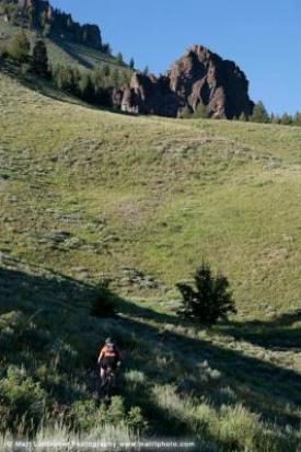
Citizens Trail #143: A continuation of Lane’s Trail that follows mellow benches through tall grass and lush spring wildflowers.
You can access the Citizens Trail #143 from the Lane's Trail portion of Trail #316, or from the lower reaches of the Griffin Butte Connector Trail #839. The Sunnyside-Lane's Trail can be accessed from the Adams Gulch Trailhead. To get to the trailhead follow the bike path or Highway 75 north to Adams Gulch Road. This intersection is about 0.7 miles north of the stoplight intersection of Hwy 75 and Saddle Road in Ketchum. Follow Adams Gulch Roads west as it crossed the Big Wood River and twists and turns through the neighborhood to a stop sign. Turn left at the stop sign and continue on the road to its end at the trailhead.
*For more detailed descriptions, topo maps, and information on the history, geology, and wildflowers of the Wood River Valley pick up a copy of Exploring Sun Valley online or find it at one of several local shops.
Photos
 |
| Adams Gulch to Citizens |


