

STANDALONE TRAIL MAP
TRAIL INFORMATION

Corral Creek Trail #325
// track pieces: 1506, // elevation pieces: 1506
Details
| Status: | Open |
| Difficulty: | Intermediate |
| Uses: | Mt Biking & Hiking & Equestrian |
| Length: | 2.7 miles |
| Start: | 6,081' |
| End: | 6,491' |
| Min: | 6,081' |
| Max: | 6,539' |
| Gain: | 1,146' |
| Loss: | -770' |
| fly your trail in 3D | |
 |
Google Earth KML file
Download KML file above, open in Google Earth to see this trail in 3D! |
| don't get lost |
| GPX file (right click to download)
Download GPX file above, upload the track to your GPS or smartphone and you'll always know where you are!! |
Trailhead Forecast
Snowfall
New Snow last 12 hours: 0.34". New Snow last 24 hours: 0.8".Description / Access Information
Corral Creek Trail #325: The out-and-back Corral Creek trail winds through open sage benches, crosses the 2007 Trail Creek burn, and traverses through dense trees to Uncle John’s Gulch. It is a fun and relatively easy bike ride, run or hike.
The main trailhead access for the Corral Creek Trail is at the Trail Creek Trailhead, located approximately 3 miles northeast of the Sun Valley Lodge on Sun Valley Road/Trail Creek Road. From the trailhead follow the wide Trail Creek Trail northeast along the creek for a short distance to the footbridge. Cross over Trail Creek and climb the trail up to the benchlands. Follow the singletrack across the field to the T-intersection. Here, turn left/northeast to follow the Corral Creek Trail uphill. The trail will enter the forest and roll up and down before again gaining a more open landscape. When you get near to Corral Creek Road the trail swings east to again enter the forest on its way to the trail's terminus near corrals in Uncle Johns Gulch.
Though considered a trail suitable to strong beginner mountain bikers by many, this trail still has its challenges. The less strong cyclists among us may want to travel up the roads paralleling this trail to gain the upper end of the trail, then descend down the trail on their return. Beginners and other less experiences cyclists may find the narrow, twisty, sometimes briefly steep nature of the trail to be more demanding than they care for. Those people may want to stick to the flatter areas of the trail near the trailhead or near the intersection of Trail Creek and Corral Creek roads. Another option for those seeking a safer, more comfortable beginner experience is to walk your bike whenever the trail conditions warrant it.
Watch for other trail users on this popular trail and be ready to yield to others.
*For more detailed descriptions, topo maps, and information on the history, geology, and wildflowers of the Wood River Valley pick up a copy of Exploring Sun Valley online or find it at one of several local shops.
*For more detailed descriptions, topo maps, and information on the history, geology, and wildflowers of the Wood River Valley pick up a copy of Exploring Sun Valley online or find it at one of several local shops.
Photos
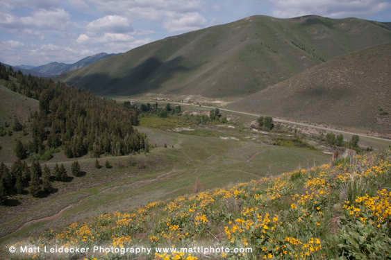 |
| View from across Corral Creek |


