

STANDALONE TRAIL MAP
TRAIL INFORMATION

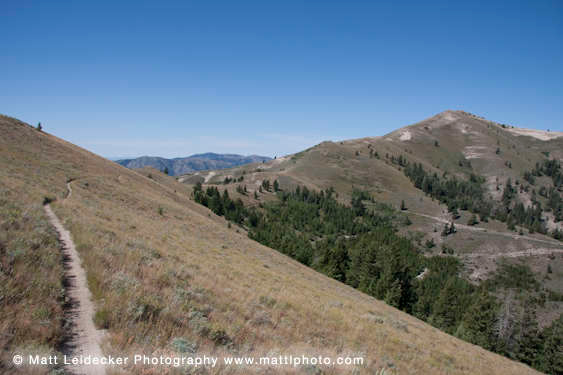
Kinsey Creek Trail #319
// track pieces: 194, // elevation pieces: 194
Details
| Status: | Open |
| Difficulty: | Advanced |
| Uses: | Mt Biking & Hiking & Equestrian & Motorcycle & eBikes |
| Length: | 3.4 miles |
| Start: | 6,067' |
| End: | 7,748' |
| Min: | 6,067' |
| Max: | 7,748' |
| Gain: | 1,772' |
| Loss: | -91' |
| fly your trail in 3D | |
 |
Google Earth KML file
Download KML file above, open in Google Earth to see this trail in 3D! |
| don't get lost |
| GPX file (right click to download)
Download GPX file above, upload the track to your GPS or smartphone and you'll always know where you are!! |
Trail Info
REMARKS:
Trails are dry and cleared. The WRTC/KRD volunteer moto crew has been busy clearing trails this summer- a huge thank you for all their work!
August 13th Forest Service reports:
• A band is on top between Kinsey Creek and Wolftone Creek.
Trailhead Forecast
Description / Access Information
Kinsey Creek Trail #319: This trail can be used as a shorter loop with the Kinsey-Curran Connector Trail #318. It can also be combined with the Wolftone-Curran Trail #160 to form a longer loop. Both routes are demanding, whichever way you approach them. Like most routes in the Deer Creek drainage, this trail offers great views up high, and it is challenging.
Background:
During the 2013 Beaver Creek fire, over 70 percent of the Deer Creek drainage burned. This was followed by torrential storms and flooding in the spring of 2014. The resulting damage to the natural and man-made components of the drainage was stunning. The area was ravaged and required a multi-year, significant rebuilding effort by the Forest Service and the local community. From 2015 to 2018, the Ketchum Ranger District rehabilitated the floodplain, restored wildlife habitat, rebuilt 20 dispersed campsites, installed trailhead facilities at two locations, and relocated 3,500 feet of forest road. They planted over 20,000 native plants and are treating the area for noxious weeds. They also rebuilt 28 miles of single-track trails in Deer Creek. These rebuilt trails form important connections to the vast system of trails found to the north of the drainage.
In total, Deer Creek restoration costs neared $1.6 million. Funding for this massive effort was largely mobilized by the 5B Restoration Coalition, a grassroots community alliance of diverse interests that strives to bring the Wood River community together to restore and enhance our lands and natural assets. Blaine County’s Land, Water and Wildlife Program, a tax-payer levy program, contributed $496,000 to the Deer Creek restoration efforts. This significant contribution provided leverage for additional funding including $188,000 from the National Forest Foundation, who is also the facilitator of the 5B Restoration Group. For more information about the 5BRC visit this web site: 5B Restoration Coalition
Directions:
At the intersection of Hwy. 75 and Deer Creek Road, take the paved Deer Creek Road west. (This intersection is about 2 miles north of Hailey, and about 9 miles south of Ketchum). Travel safely and slowly through the neighborhood to cross the bridge over the Big Wood River. The road turns to gravel after about 3 miles.
From the highway it's about 10.5 miles to the end of the Deer Creek Road at the Deer Creek Traihead. To reach the Kinsey Creek Trail #319 from the trailhead proceed west onto the Deer Creek Trail. In less than 1/2 mile the Kinsey Creek Trail will be on the left/south.
*For additional descriptions, maps, and information on the history, geology, and wildflowers of the Wood River Valley pick up a copy of Exploring Sun Valley online or find it at one of several local shops.
Photos
 |


