

STANDALONE TRAIL MAP
TRAIL INFORMATION

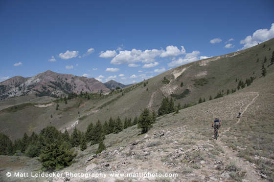
Wolftone-Curran Trail #160
// track pieces: 1910, // elevation pieces: 1910
Details
| Status: | Open |
| Difficulty: | Advanced |
| Uses: | Mt Biking & Hiking & Equestrian & Motorcycle & eBikes |
| Length: | 10.9 miles |
| Start: | 6,515' |
| End: | 6,331' |
| Min: | 6,331' |
| Max: | 7,953' |
| Gain: | 2,680' |
| Loss: | -2,861' |
| fly your trail in 3D | |
 |
Google Earth KML file
Download KML file above, open in Google Earth to see this trail in 3D! |
| don't get lost |
| GPX file (right click to download)
Download GPX file above, upload the track to your GPS or smartphone and you'll always know where you are!! |
Trail Info
REMARKS:
Trails are dry and cleared. The WRTC/KRD volunteer moto crew has been busy clearing trails this summer- a huge thank you for all their work!
August 20, Forest Service Reports:
-A band is at the top of Kinsey Creek. In the next couple of days this band will trail down into Deer Creek and into Panther Gulch from there they will turn and head off the allotment via Wolftone. (Trails 160 & 319)
Trailhead Forecast
Description / Access Information
Wolftone-Curran Trail #160: This roughly eleven-mile long trail is often combined with the lowest portion of the Deer Creek Trail #158, a section of Deer Creek Road, and Wolftone Road. Doing so allows for a clockwise loop that is about 18 miles long. It offers great views and mountain bikers appreciate the route's 5-mile single-track descent down Curran Gulch. The traverse from Wolftone to Curran Gulch crosses both sides of an 8,000-foot ridge that often is blooming with wildflowers.
The loop is also approachable as a counter-clockwise trip. When done this way, the loop ending descent isn't on single-track, but it is still a fun drop. Watch for, and yield to climbers, and others out enjoying the trails. Slow down as you approach blind corners, and anticipate that others may be coming toward you.
The first half of the clockwise route follows old mining routes and two-tracks. It is not the most pristine option for hikers, but those with good route finding skills can take off-trail excursions on some for the area's adjacent ridge lines and peaks. Short scrambles lead to panoramic views of the Pioneer Mountains.
Note: For details about some of the nearby peaks you can gain, from areas along the #160 Trail, see the descriptions, topo maps, and other information found on the history, geology, and wildflowers of the Wood River Valley in the book, Exploring Sun Valley. You can find it online, or in local stores.
Which ever way you approach the trail, it's a good idea to have a good map of the area and a compass with you. On trails new to you its good to go with someone familiar with the area. Nearly all of the main trail intersections in the drainage are signed, but in a few places you have some options where a wrong turn could get you lost. Many people use their smartphones, and a preferred map-application, to help them stay on track. A .gpx file for the #160 trail can be uploaded to your phone or GPS unit. A link to a .gpx file for the #160 trail can be found on this page; its just below the ride's elevation profile.
Back to the description of the trail. As mentioned earlier, when climbing up the trail from the end of Wolftone Road, the route is over two-track roads, intermixed with sections of singletrack.
As the trail climbs higher it includes some sections that are more singletrack in character, then you hit a signed intersection after an incised creek-crossing. Here, the singletrack meets a two-track, where you will want to stay to the right; to stay on the #160 Trail. Shortly, the trail passes through a more meadow-like area interspersed with some nice larger trees. Then the trail climbs a steep rough gravel two-track section. The steep road section seems to go on and on. Some local riders refer to this steep climb as "Palm Tree Hill." Climbing the grade was said to have had one rider hallucinating in the heat of a summer climb on the trail. He reported that the lone pine tree near the top appeared to him as palm tree. Anyway, it's a tough climb.
Eventually you gain a saddle and descend. The trail is still road-like here - watch for big loose rocks and other rough sections. At a fork, stay left to gain a new reroute of the trail. The wide ATV-accessible trail climbs steeply at first, then breaks over to traverse over to a big saddle at the head of Kinsey Gulch.
Once over at the top of Kinsey, you have a number of options available to you. To stay on the #160 Trail, follow along the ridge to the west to a nearby sign for the #160 Trail. Follow the sign to drop onto a very short, crazy-steep, section of single-track. This trail drops to carry you onto the other side of the mountain; onto the more south and west facing aspects of the ridge. The trail immediately swings right, where it meets a two-track section of trail. Stay right onto the two-track-like trail. The two-track begins traversing along the hillside, heading you in a westerly direction, before bending more to the north. The trail changes back and forth a bit from two-track to singletrack, and at one point the trail makes a split where a singletrack portion goes steeply up. You can take the steep singletrack, or stay on the two-track, as they soon join together again.
Eventually, the trail begins to drop in earnest, making a neat swing down the Curran drainage. The Curran side of the trail is a sweet twisty ribbon. Descending on it is a pleasure. People like to climb up it too, so watch for, and yield to others, and be careful as you approach blind corners. Clockwise loopers - you will find the end of the trail at a crossing of Deer Creek, and the #160 Trail's intersection with the Deer Creek Trail. Turn right, if you are doing the loop, and descend back to your starting point. Please note that the ride out is not 100% downhill; there are some minor "ups" along the way.
Generally speaking, the trails in the Deer Creek drainage are not for the faint of heart, the less experienced, or the ill-prepared. While still considered a "front-country" experience by many, the trails are rather deep in, and somewhat removed from things like cell phone service. You may want to think of the area as typifying a more backcountry-type experience, to help you as you make preparations for a visit, and your safe return out.
Be mindful that portions of your route will be through burned areas. Beware of falling trees and limbs, rolling rocks and flash floods. Watch the weather and stay out if the forecast is for stormy weather or high winds. Trees come down all the time in a burned forest, winds or not, and despite the best efforts of the FS Trail Crew, and area volunteers, some trees may be down along your intended route.
Accessing the trails in the Deer Creek drainage takes some effort. Deer Creek Road starts out pretty nice, but depending on when it was last graded, and the time of the year, it can get pretty rough. As you get deeper in, the road narrows, and there are a lot of blind corners that you need to approach slowly. It takes a while to get in and out, but if it isn't the high-summer season, or hunting season, the area can be relatively quiet, and somewhat less traveled.
Background:
During the 2013 Beaver Creek fire, over 70 percent of the Deer Creek drainage burned. This was followed by torrential storms and flooding in the spring of 2014. The resulting damage to the natural and man-made components of the drainage was stunning. The area was ravaged and required a multi-year, significant rebuilding effort by the Forest Service and the local community. From 2015 to 2018, the Ketchum Ranger District rehabilitated the floodplain, restored wildlife habitat, rebuilt 20 dispersed campsites, installed trailhead facilities at two locations, and relocated 3,500 feet of forest road. They planted over 20,000 native plants and are treating the area for noxious weeds. They also rebuilt 28 miles of single-track trails in Deer Creek. These rebuilt trails form important connections to the vast system of trails found to the north of the drainage.
In total, Deer Creek restoration costs neared $1.6 million. Funding for this massive effort was largely mobilized by the 5B Restoration Coalition, a grassroots community alliance of diverse interests that strives to bring the Wood River community together to restore and enhance our lands and natural assets. Blaine County’s Land, Water and Wildlife Program, a tax-payer levy program, contributed $496,000 to the Deer Creek restoration efforts. This significant contribution provided leverage for additional funding including $188,000 from the National Forest Foundation, who is also the facilitator of the 5B Restoration Group. For more information about the 5BRC visit this web site: 5B Restoration Coalition
Directions:
At the intersection of Hwy. 75 and Deer Creek Road, take the paved Deer Creek Road west. (This intersection is about 2 miles north of Hailey, and about 9 miles south of Ketchum). Travel safely and slowly through the neighborhood to cross the bridge over the Big Wood River and proceed out the drainage. Deer Creek Road changes to a gravel surface after about 3 miles.
From the highway its about 8.1 miles out Deer Creek Road to its intersection with the Wolftone Road #102 on the left/south. To get to the start of the Wolftone-Curran Trail, from the Wolftone drainage side, proceed up Wolftone Road. The road is about 3 miles long and it ends at a cul-de-sac where there is room to park several vehicles. Do not block the road or pull-through area as others pulling a trailer may need to pull all the way around the small road-ending loop.
In the early spring, when Deer Creek is swollen, you may want to first check the creek crossing at the intersection of Deer Creek Trail and the Curran side of the Wolftone-Curran #160 Trail. Doing so before starting a planned loop outing that utilizes the #160 Trail will allow you to better determine the best way to travel the loop, and if the creek is too swollen to safely cross, you can choose another outing in the drainage.
For those wishing to approach the trail from its western end in Curran Gulch, proceed up the Deer Creek Road from the intersection of Deer Creek Road and Wolftone Road. In about 2.2 miles you will arrive at the end of the Deer Creek Road #097 at the FS Deer Creek Picnic Area. (FYI - The picnic area is incorrectly identified as "Deer Creek Campground" on this site's Google base-map layer.) There is room to park several vehicles at the Deer Creek Trailhead site. It includes a kiosk with a map and interpretive information, and a vault toilet.
*For additional descriptions, maps, and information on the history, geology, and wildflowers of the Wood River Valley pick up a copy of Exploring Sun Valley online or find it at one of several local shops.
Photos
 |


