

STANDALONE TRAIL MAP
TRAIL INFORMATION

Warfield-South Fork Trail #151
// track pieces: 880, // elevation pieces: 880
Details
| Status: | Open |
| Difficulty: | Advanced |
| Uses: | Mt Biking & Hiking & Equestrian & Motorcycle & eBikes |
| Length: | 9.17 miles |
| Start: | 6,353' |
| End: | 6,925' |
| Min: | 6,353' |
| Max: | 8,244' |
| Gain: | 2,654' |
| Loss: | -2,085' |
| fly your trail in 3D | |
 |
Google Earth KML file
Download KML file above, open in Google Earth to see this trail in 3D! |
| don't get lost |
| GPX file (right click to download)
Download GPX file above, upload the track to your GPS or smartphone and you'll always know where you are!! |
Trailhead Forecast
Snowfall
New Snow last 12 hours: 0". New Snow last 24 hours: 0".Description / Access Information
Warfield-South Fork Trail #151: Repairs have been made to the trail following flooding that occurred in the drainage in 2017, but the trail remains rough and rowdy with lots of loose rocks, sticks in the tread, and ruts.
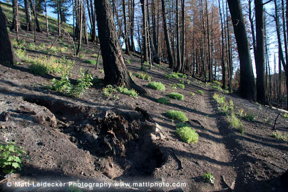
Burned areas, and other areas of the forest, continue to see trees coming down during storms or wind events. Plan accordingly.
The “trailhead” at the north end of this trail is not well-marked and has room for only two or three cars. There is no bridge over Warm Springs Creek, so don’t attempt a crossing at high flows in the spring. The access at the southwest end of the trail is off of FS Road 033. There is a creek crossing at this southwest end of the trail too. Entering Meadow Creek here is not recommended during periods of high flow.
The upper branches of the Warfield Creek trail were badly burned in 2007 and were re-routed during the summer of 2010. The new trail makes a great, rugged route into Red Warrior Creek or down the South Fork of Warm Springs. The Warfield trail passes through several different rock types and is a great hike for those interested in geology. Warfield Creek does not see much traffic and the mid-summer wildflowers are often plentiful.
Directions: From downtown Ketchum, bear left onto Warm Springs Road and follow it to the end of the pavement (4.8 mi). Stay on the main dirt road to a small spur parking lot .6 miles past the Red Warrior turn-off (6.8 mi).
*For more detailed descriptions, topo maps, and information on the history, geology, and wildflowers of the Wood River Valley pick up a copy of Exploring Sun Valley online or find it at one of several local shops.
Photos
 |


