

STANDALONE TRAIL MAP
TRAIL INFORMATION

Trail #146 - Old Adams Gulch Road Trail and Eve Gulch Trail
// track pieces: 180, // elevation pieces: 180
Details
| Status: | Open |
| Difficulty: | Advanced |
| Uses: | Mt Biking & Hiking & Equestrian & Motorcycle & eBikes |
| Length: | 7 miles |
| Start: | 5,970' |
| End: | 7,660' |
| Min: | 5,968' |
| Max: | 7,972' |
| Gain: | 2,337' |
| Loss: | -647' |
Trail Info
REMARKS:
Ketchum Ranger District reports most of the front country trails are open and cut out.
Trailhead Forecast
Description / Access Information
Trail #146 - Old Adams Gulch Road Trail and Eve Gulch Trail: This is the main road-like trail that runs through the bottom of the Adams Gulch drainage, and then up to the top of Eve Gulch. The low portion of the route, from the Adams Gulch Trailhead to the intersection with the Trail #177, is known as the Old Adams Gulch Road Trail. Above the intersection with the Trail #177 the trail is named Eve Gulch Trail.
The entire #146 Trail has a seasonal designation for motorcycle and e-bike use and is open to those uses from 5/1 through 11/30 of each year.
The Eve Gulch portion of the drainage was severely burned during the Castle Rock Fire, and much of the trail was rerouted by the Ketchum Ranger District during the summer of 2009. The Eve Gulch section contours up to gain 1,400-feet as it utilizes a number of in-sloped turns and areas of more direct climbing.
This is an excellent out-and-back mountain bike ride, and a lot of runners like it too. For those venturing up the Eve Gulch portion of the route, consider that most people turn around as they near the high point of the trail, near an old sign that says: "Trail." The trail does continue on in Eve Gulch, soon passing its actual high point, and then dropping as it passes a couple of ramshackle hunting cabins before connecting with an old mining road that can be taken to the West Fork Road #049. The West Fork Road is very steep and narrow. It forms a connection to Warm Springs Road.
As mentioned above, West Fork Road #049 drops down precipitously before making a connection to Warm Springs Road #227. This descent is poor, as it is so steep that your brake rotors are sure to be glowing red hot by the bottom. Once at Warm Springs Road riders can turn left/northeast to head back into Ketchum. Some cyclists ride this loop in the other direction, climbing up West Fork Road #049 to gain the higher reaches of Eve Gulch Trail before descending down into Adams Gulch. Riding the route in this direction (clockwise) will have you pushing your bicycle uphill for long stretches of the super steep W. Fork Rd. #049, but the descent on Eve Gulch Trail is really good, and you have the option of hitting the Forbidden Fruit Flow trail near the bottom of Eve.
Directions: You can access the Old Adams Gulch Road Trail #146 from the Adams Gulch Trailhead. To get to the trailhead follow the bike path or Highway 75 north to Adams Gulch Road. This intersection is about 0.7 miles north of the stoplight intersection of Hwy 75 and Saddle Road in Ketchum.
Follow Adams Gulch Road west as it crossed the Big Wood River and twists and turns through the neighborhood to a "T"-intersection and a stop sign. Turn left at the stop sign and continue on the road to its end at the trailhead.
The trailhead features a trailhead kiosk with maps and route ideas for the Adams Gulch area, a vault toilet, a couple of picnic tables and a fire ring down near the cottonwoods and creek. The trailhead is for day-use only. No camping. Dogs must be on leash when they are within 200 feet of the trailhead.
*For more detailed descriptions, topo maps, and information on the history, geology, and wildflowers of the Wood River Valley pick up a copy of Exploring Sun Valley online or find it at one of several local shops.
Photos
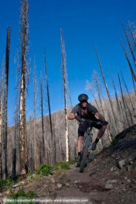 |
| In the burn on Eve's Gulch |


