

STANDALONE TRAIL MAP
TRAIL INFORMATION

Quigley Loop Trail
// track pieces: 3273, // elevation pieces: 3273
Details
| Status: | Open |
| Difficulty: | Beginner |
| Uses: | Mt Biking & Hiking & Equestrian & eBikes |
| Length: | 7 miles |
| Start: | 5,378' |
| End: | 5,398' |
| Min: | 5,373' |
| Max: | 5,634' |
| Gain: | 877' |
| Loss: | -877' |
| fly your trail in 3D | |
 |
Google Earth KML file
Download KML file above, open in Google Earth to see this trail in 3D! |
| don't get lost |
| GPX file (right click to download)
Download GPX file above, upload the track to your GPS or smartphone and you'll always know where you are!! |
Trail Info
REMARKS:
Quigley Loop, the pump track, Flow Lines, and Jump Lines are open!
Trailhead Forecast
Description / Access Information
Quigley Loop Trail: Initially built in 2019 by the BCRD, the Quigley Loop Trail was improved and lengthened in 2023. It is about 7 miles to complete the loop, which is rated as easy, though you will find some short pulls that are more challenging. The trail is just east of Hailey and it travels through the western end, or mouth, of Quigley Canyon.The trail can be accessed off of Quigley Canyon Road or at the BCRD Quigley Trails Park at the end of Fox Acres Road. The trail is open to bicyclists, hikers and equestrians and is built wide to accommodate side-by-side traffic or use by hand-cycles. Please obey posted signs and enjoy the new trail safely and responsibly.
Your use of this area is permitted by the private landowner, Quigley Farm. Please respect private property by limiting your access to designated trails. This property is permanently protected by a conservation easement with the Wood River Land Trust. The Quigley Loop Trail was a collaborative effort with Quigley Farm, the Wood River Land Trust, and the BCRD.
*For more detailed descriptions, topo maps, and information on the history, geology, and wildflowers of the Wood River Valley pick up a copy of Exploring Sun Valley online or find it at one of several local shops.
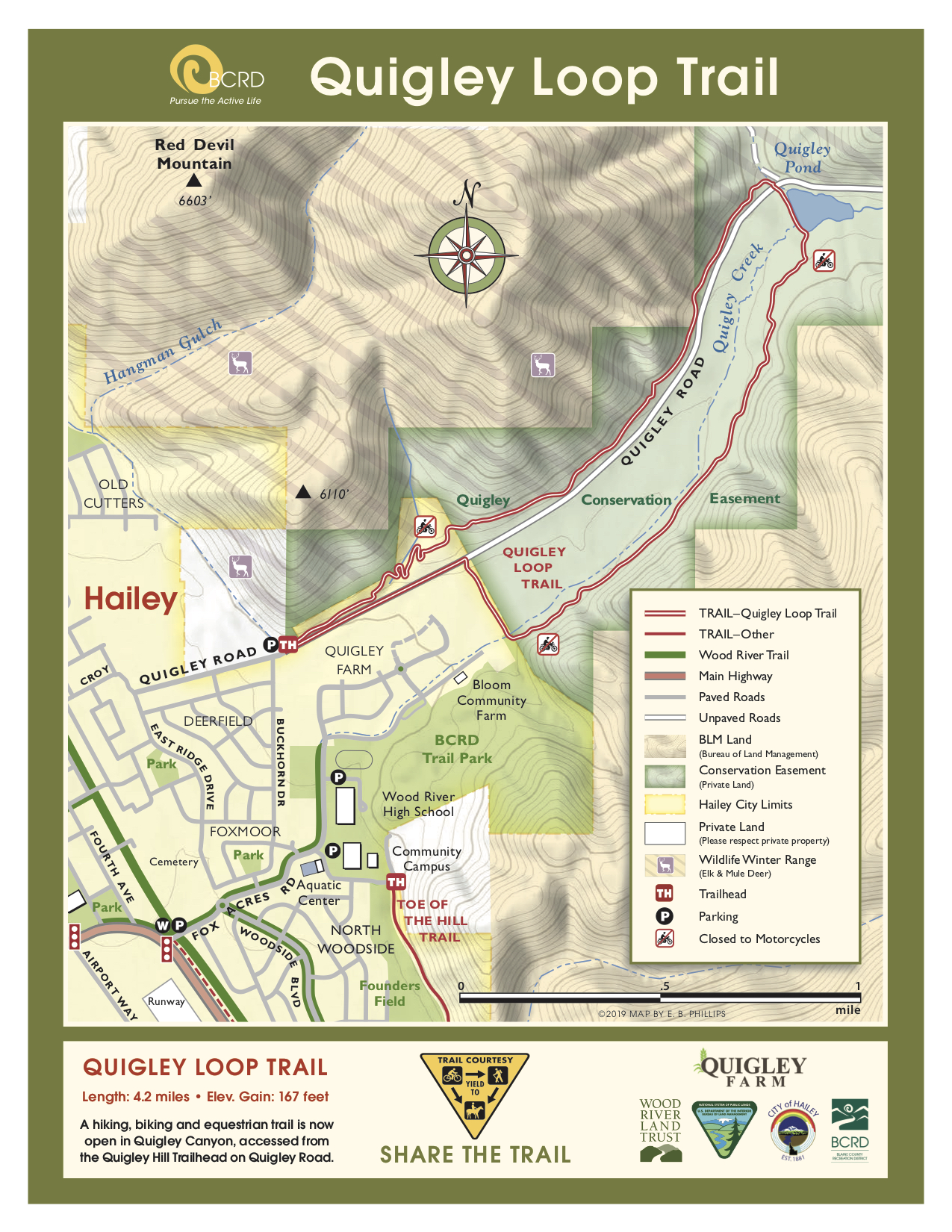
Access: Trailhead and parking is available on Quigley Road. Quigley Road is found on the east end of Hailey and is accessed through residential neighborhoods. Please drive safely if you are motoring to Quigley for your outing. You can also choose to access the trail at the BCRD Quigley Trails Park at the end of Fox Acres Road. The speed limit along Fox Acres Road is 15 mph and it passes by the BCRD Pool, the Community Campus, and Wood River High School. Drive safely.
Directions: For Quigley Canyon Road access: In Hailey, at the intersection of Hwy 75 and Croy Street, head east on Croy Street. (Croy St. intersects with Hwy 75/Main Street one block south of the main downtown stoplight intersection). Travel east on Croy Street. After crossing the bike path the street makes a right hand turn and becomes East Ridge Drive. Turn left almost immediately at the next intersection, which is Quigley Road. Follow the paved portion of Quigley Road for about a quarter to a small dirt parking area on the left at the start of the native surface portion of Quigley Road. From the parking/trailhead area, the Quigley Loop Trail can be accesses by heading further east up Quigley Road. Look for the signs marking the trail.
For access at the BCRD Quigley Trails Park: In Hailey, at the intersection of Hwy 75 and Fox Acres Road head east on Fox Acres Road, staying on Fox Acres Road as it passes the BCRD pool, Community Campus, and Wood River High to the paved entrance road into the Quigley Trails Park on the right. Turn right and follow the entrance road in a short distance to the TH parking on the right.
*For more detailed descriptions, topo maps, and information on the history, geology, and wildflowers of the Wood River Valley pick up a copy of Exploring Sun Valley online or find it at one of several local shops.


